What's happening
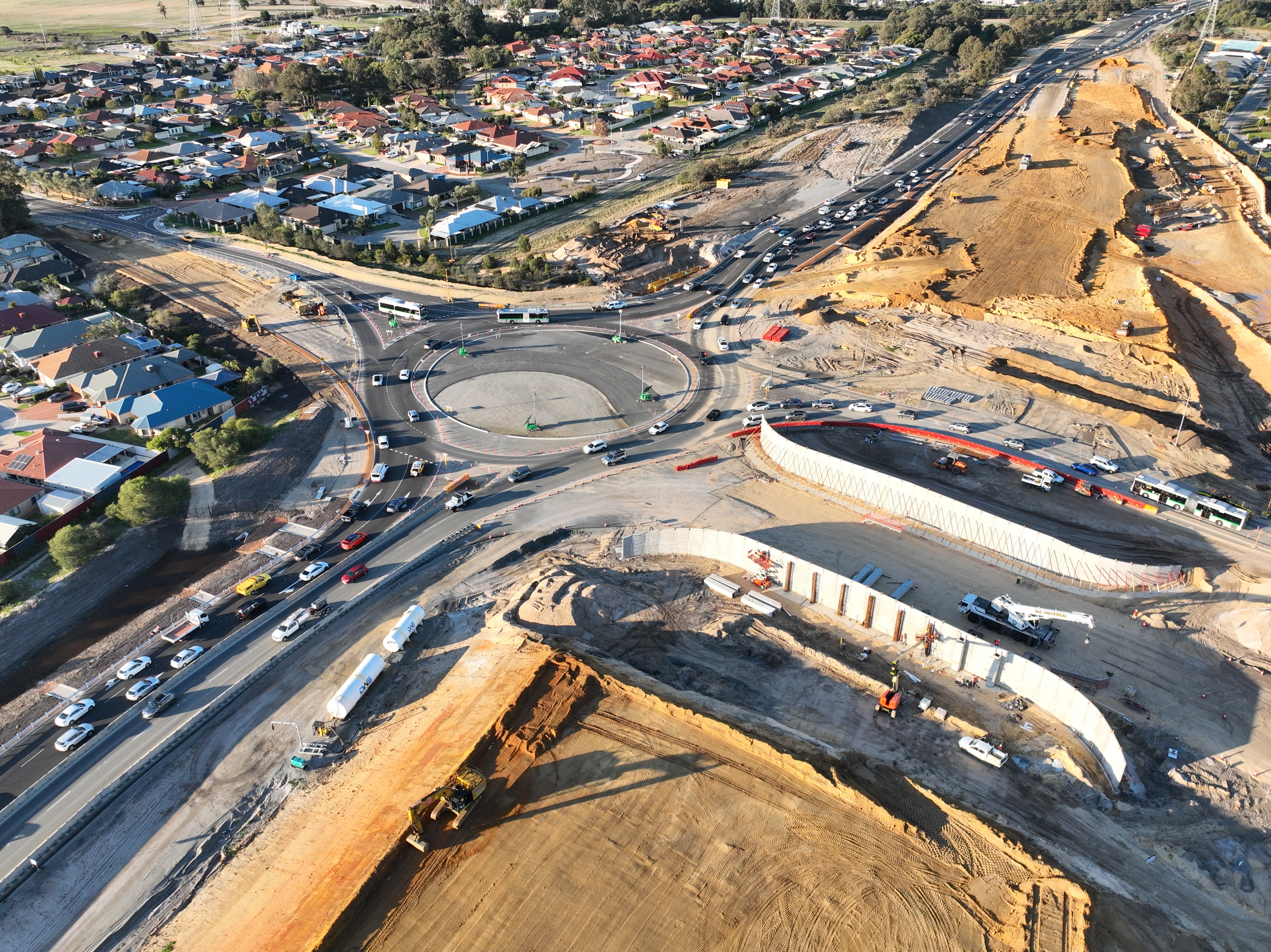
Construction of the future Reid Highway bridge over Altone Road is continuing to gather momentum, with significant progress being made on the bridge foundations and embankments.
Progress also continues at the Drumpellier Drive / Daviot Road interchange, with abutment wall panels now fully installed and backfilling of the bridge embankments well underway.
Progress on shared path underpasses
Construction is now underway on several new underpasses along the Reid Highway Principal Shared Path (PSP), including extensions to the existing Grandis Road underpass.
These structures will enhance connectivity for pedestrians and cyclists, providing safer and more convenient travel through the area. Current construction activities include formwork and reinforcement installation, concrete pours, and the installation of precast units.

Read our July Construction Update.
Are you interested in working on the project? Contact enquiries@mainroads.wa.gov.au to be connected with a project representative or click to express interest.
PROJECT RATIONALE AND BENEFITS
Why is this project required?
The intersections of Altone Road and Drumpellier Drive are two of only five remaining signalised intersections on Reid Highway. Each intersection experiences congestion due to the increasing volumes of traffic on the highway and intersecting roads, resulting from ongoing residential and commercial development in Perth’s north-eastern corridor.
In addition, Reid Highway is a strategic east-west freight route. Following the extension of Tonkin Highway to Muchea, these new interchanges will provide a high standard, continuous route for heavy vehicles to deliver safe and efficient freight movements.
What are the benefits of the project?
The project will:
- Improve safety for residents and tourists by enabling vehicles to pass freely through two busy intersections.
- Improve traffic flow by removing two sets of traffic lights
- Facilitate more efficient, reliable movement of freight
- Enhance cyclists' access to the Swan Valley.
Why weren’t these intersections upgraded as part of the previous Reid Highway Dual Carriageway project to minimise disruption?
The previous project addressed the final single-lane section of the highway, however, at the time funding did not include upgrades to the Altone Road and Drumpellier Drive intersections.
The Dual Carriageway project did not make any interim improvements to the Altone Road and Drumpellier Drive intersections in anticipation of the Interchanges project being funded in the future.
SCOPE AND FUNDING
What is the scope of the project?
The current project scope includes:
- A new bridge on Reid Highway, passing over Altone Road intersection, with connectivity between Altone Road and Reid Highway to be maintained via entry and exit ramps and roundabouts.
- A new bridge connecting Drumpellier Drive with Daviot Road over Reid Highway with entry and exit ramps onto Reid Highway.
- Modifications to Reid Highway from Altone Road to Arthur Street to support the new interchanges.
- Modifications to the existing Tattler Way roundabout to provide south-bound left in / left out access to residential area.
- A Principal Shared Path (PSP) bridge for cyclists and pedestrians passing over the Altone Road on ramp and new PSP underpasses beneath the Altone Road off ramp and Daviot Road. Collectively these upgrades will provide an uninterrupted path network from West Swan Road to Malaga Drive.
- Landscaping and urban design.
Who is funding the project?
This $225 million project is jointly funded (50% each) by the State and Australian Governments.
DESIGN CONSIDERATIONS
How will each interchange be configured?
The concept design for the Drumpellier Drive / Daviot Road interchange is similar to projects recently constructed at Roe Highway and Kalamunda Road and at Roe Highway and Karel Avenue, with connectivity between the highway and the intersecting roads maintained through on and off ramps and a “dog bone” (elongated) roundabout.
The configuration of the Altone Road intersection is similar, however, Reid highway will flow over, rather than beneath, the new roundabout.
Why is Reid Highway passing over Altone Road but under Drumpellier Drive / Daviot Road?
The configuration of the project has been determined by the available space around each intersection and the proximity of residential properties. For instance, elevating Altone Road rather than Reid Highway would have resulted in the bridge being located very close to residents north of Reid Highway.
At Drumpellier Drive, there is considerably more space to the north and south of the intersection and therefore a bridge passing over Reid Highway is a more appropriate solution in this location.
Why are roundabouts preferred to traffic lights?
Roundabouts have been selected in this location to maintain traffic flow while eradicating stop-start traffic on Drumpellier Drive / Daviot Road and Altone Road. In addition, roundabouts avoid the installation and maintenance costs associated with traffic signals. Finally, the design of the roundabouts will necessitate a reduction in traffic speed on the approaches and eradicate the risk of high-impact T-bone crashes.
Why does Tattler Road need to become left-in left-out?
The existing roundabout at Altone Road and Tattler Way is approximately 300 metres from the intersection of Altone Road and Reid Highway.
The access ramps and merging distances for the new interchange at Altone Road and Reid Highway will extend as far as Tattler Way, creating a potentially dangerous right turn movement for traffic.
Residents living on Tattler Way and nearby streets will be able to access Altone Road in a southbound direction only.
The existing roundabout at Altone Road and Bennett Springs Drive will remain unchanged and continue to provide access in all directions.
What is the approximate height of the two bridges?
The clearance at the Reid Highway bridge over Altone Road will be 5.4m and the clearance at the Drumpellier Drive and Daviot Road bridge over Reid Highway will be 6.1m
NOISE, AMENITY, ENVIRONMENT AND HERITAGE
Is the project likely to increase noise levels?
It is unlikely that the project will lead to a significant increase in noise levels. Free-flow traffic movement through the intersections may reduce noise due through the eradication of stop-start traffic movement and associated air breaking by heavy vehicles. In addition, resurfacing this section of the highway with new asphalt will result in a quieter surface than what is presently in place.
What noise mitigation measures are proposed as part of the project?
The project is being delivered in accordance with State Planning Policy 5.4 (SPP5.4) Road and Rail Noise. Under this policy, Main Roads is required to ensure noise limits at the boundaries of its projects are contained within the established acceptable parameters.
The current concept design provides additional noise mitigation along various sections of the highway, where provisional noise modelling indicates noise levels will exceed established parameters by 2041. This includes sections of new noise walls in locations where walls are not currently in place or where existing estate boundary walls do not adequately meet noise abatement criteria.
In addition to meeting prescribed policy criteria, the project will address current disparities in wall provision along affected sections of the highway, created by the differing styles of estate boundary walls.
Will residents’ back yards and properties be visible from the bridges?
A thorough screening assessment has been conducted. In addition to the proposed noise walls, screening will be installed on each of the new bridges and on and off ramps to ensure vehicles, pedestrians and cyclists will not be able to see into neighbouring properties from the road or path level.
How much vegetation will need to be cleared?
Some clearing of native vegetation (approximately 2.1 hectares) will be required for the new interchanges and associated works, particularly on the south-eastern side of the Reid Highway and Daviot Road interchange. Relevant State environmental approvals are in place.
Upon completion of the project, the areas around each interchange will be revegetated with native vegetation.
Will the project impact the Bennett Brook, which is a culturally sensitive location?
The existing section of the highway passing over Bennett Brook, as well as the Brook itself, will not be affected by the project.
PEDESTRIANS AND CYCLISTS
What improvements will the project provide for pedestrians and cyclists?
The existing Principal Shared Path (PSP) along Reid Highway will be modified to flow freely through each of the interchanges. This will be achieved through construction of a bridge for cyclists and pedestrians passing over the Altone Road on ramp and new PSP underpasses beneath the Altone Road off ramp and Daviot Road. These changes will provide an uninterrupted path network from West Swan Road to Malaga Drive.
How will pedestrians and cyclists be affected by construction?
There is likely to be some changes and / or detours to the existing PSP along Reid Highway during the construction period. This will be considered by our Contractor in the development of their Traffic Management Plan, in consultation with path users, cycling groups and other key stakeholders.
What is the impact of the project on the new Grandis Road underpass?
Some modifications will be required at each end of the Grandis Road underpass to improve connectivity to the shared path network. There is also likely to be some disruption and potential closures of the underpass during construction of the Reid Highway and Drumpellier Drive / Daviot Road interchange.
COMMUNITY
How is the project engaging with the community?
The project team is committed to working with local residents and other interested parties to ensure the impacts of construction can be managed appropriately.
An introductory project brochure was distributed to over 9,000 local residents in November 2022 and a community drop-in session was held in Dayton in June 2022.
As the project progresses, updates will be provided in the form of regular newsletters, construction updates and roadworks updates.
We will utilise a broad range of communication methods, from e-bulletins and social media, through to hard copy correspondence and face to face meetings. We encourage ongoing feedback from the community, businesses and road users about the progress of the project and will incorporate this feedback wherever possible.
CONSTRUCTION CONSIDERATIONS
How will the construction program impact traffic on Reid Highway and the adjoining intersections?
The project will be carefully staged to ensure traffic impacts on Reid Highway and the intersections of Altone Road, Drumpellier Drive, and Daviot Road are minimised as far as possible. A staging plan and construction methodology will be provided by the prospective Contractor for consideration as part of the project’s tender process later this year.
How will residential properties be protected during construction?
As part of the project’s Construction Management Plan, the prospective Contractor will propose measures to ensure vibration and dust are minimised as far as is practicably possible. Vibration will be monitored in strategic locations to ensure the project does not exceed compliance levels. In addition, property owners of buildings and structures located within 100 metres of the project boundary will be offered a pre-condition survey before construction commences to establish the condition of all properties and structures that may be affected by construction activities.
Property owners will be encouraged to engage with the contractor on an ongoing basis if any changes to the condition of their properties become noticeable during the works.
FUTURE PLANS
What are the plans for the intersection of Reid Highway and West Swan Road?
Planning and development for a new interchange at Reid Highway and West Swan Road is underway, however, there is no current delivery timetable for the works. Some minor upgrades were made to the intersection in 2020 to maintain traffic flow during the immediate future. These upgrades included a new turning pocket from Reid Highway westbound to West Swan Road northbound.
Are there plans to upgrade the remaining signalised intersections on Reid and Roe Highways?
Early planning is ongoing to replace the remaining signalised intersections on Reid and Roe Highway (at Erindale Road, Great Northern Highway, Toodyay Road and Morrison Road) with new bridges / interchanges. These future projects are also unfunded.
Reid Highway is a strategic east-west route in Perth’s north between Marmion Avenue and Roe Highway. These new interchanges will facilitate more efficient and reliable movement of freight while improving safety, traffic flow and urban amenity for residents and tourists.
The current project scope includes:
- A new bridge on Reid Highway, passing over Altone Road intersection, with connectivity between Altone Road and Reid Highway to be maintained via entry and exit ramps and roundabouts.
- A new bridge over Reid Highway connecting Drumpellier Drive with Daviot Road, with entry and exit ramps onto Reid Highway.
- Modifications to Reid Highway from Altone Road to Arthur Street to support the new interchanges.
- Modifications to the existing Tattler Way roundabout to provide south-bound left in / left out access to residential area.
- A Principal Shared Path (PSP) bridge for cyclists and pedestrians passing over the Altone Road on ramp and new PSP underpasses beneath the Altone Road off ramp and Daviot Road. These changes will provide an uninterrupted path network from West Swan Road to Malaga Drive.
- Additional noise and screening walls in various locations along Reid Highway.
Project Updates
- Construction Update - July 2026 - PDF (739 KB)
- Construction Update - April 2026 - PDF (594 KB)
- Construction Update - March 2026 - PDF (737 KB)
- Construction Update - February 2026 - PDF (232 KB)
- Construction Update - December 2025 - PDF (588 KB)
- Construction Update - November 2025 - PDF (1.32 MB)
- Construction Update - October 2025 - PDF (486 KB)
- Construction Update - September 2025 - PDF (228 KB)
- Construction Update - August 2025 - PDF (258 KB)
- Project Update - July 2025 - PDF (1.2 MB)
Project Information
- Sustainability Fact Sheet - May 2026 - PDF (286 KB)
- Noise Wall Fact Sheet - May 2026 - PDF (745 KB)
- Frequently Asked Questions - September 2025 - PDF (235 KB)
- Property Condition Survey Fact Sheet - August 2025 - PDF (154 KB)
- Project Overview - January 2024 - PDF (12.2 MB)
- Project Overview – May 2023 – PDF (1.32 MB)
- Frequently Asked Questions - April 2023 - PDF (170 KB)
Map
Media statements
- Reid Highway interchange upgrades underway - 24 December 2025
- Contract award for major Reid Highway upgrades - 24 July 2025
- Joint media statement - Preferred proponent named for delivery of new Reid Highway interchanges - 18 January 2024
Funding
-
This $225 million project is jointly funded (50% each) by the Australian and State Governments.
safety and flow
route for freight
shared path for cyclists and pedestrians